
Remote Sensing Turbidity Maps
For over 12 years IMDC has been conducting remote sensing research projects in cooperation with VITO – TAP and with the support of BELSPO (Belgian Science Policy) to develop know how and software tools. These tools can transform airborne (ORMES), satellite-based (RESORT) and dronebased (DRONESED) images to maps with surficial suspended sediment concentrations.
Images of the sediment concentration are essential if accurate advice is to be given to select new salvage, dredging, dredge spoil placement locations, harbour/LNG-terminal sites or sensitive areas, to estimate possible movements of sediment clouds and to calibrate sediment transport models. Its spatial resolution and coverage cannot be matched by more conventional measurement methods. To support IMDC in their activities, a software application was developed in the ORMES project (and refined and perfected in the RESORT project) which provides suspended sediment maps from remote sensing images in an efficient way.
Simultaneously with the remote sensing (RS) campaigns field surveys took place. Using these field data and the high resolution RS data, a reliable semi-empirical algorithm has been developed to derive near-surface suspended matter maps in an operational way. The produced TSM maps show good agreement with known variations of the suspended sediment content over the tidal cycle. The tool has also been tested at various ongoing projects in Qatar and Panama. These optically different types of waters proved an ideal testing ground for the SEDMAP software. Satellite imagery was obtained simultaneously with and in-situ sampling campaign. In both cases valuable spatial information was obtained on the spatial distribution at a given time of a turbidity plume. The tool is applicable all over the world as long as airborne or satellite imagery is available.
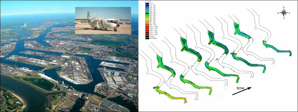
In 2015-2016 funding was obtained for aerial observations of sediment concentration using drones. The different algorithms needed to process the images taken from the drone and to calibrate the reflectance to sediment concentrations were developed. In our Synapps platform or any open geodata platform these images can be visualised in movies of sediment maps and help clients to identify small scale sediment behaviour at harbour inlets, tidal areas and close range around dredge activities.
For more information: https://eo.belspo.be/en/stereo-in-action/projects/drone-based-sediment-mapping-dredging-operations
Data
- Client: Research project with the support of Belspo
related references
-

-
InnovationInnovation
-
Hydro-Environmental ServicesHydro-Environmental Services
-
Coasts & EstuariesCoasts & Estuaries
-
Marine, Dredging & Port EngineeringMarine, Dredging & Port Engineering
-
-

-
Water ComputingWater Computing
-
InnovationInnovation
-
Marine, Dredging & Port EngineeringMarine, Dredging & Port Engineering
-
MonitoringMonitoring
-
-

-
Blue EnergyBlue Energy
-
InnovationInnovation
-